"I know the developer is planning on putting trees along Executive Center Drive and Woodhollow to screen the high rises, not sure if these trees are as sizeable as the protected ones." A protected tree is 19 inches in diameter (measured 4.5 ft. from the ground). The developer will not be planting those because they would be transplants that cost $100K each . The planted trees will be at most 4 inch in diameter and will not grow for 10 years while they get over the shock of being transplanted. You probably know these already, but just in case: Search any permit at this link, including tree permits (permit type box towards bottom):https://www.austintexas.gov/devreview/a_queryfolder_permits.jsp Site plans don't have tree permits because these are part of the site plan. For those, you look for the landscaping page and the tree survey table that shows removed trees:# 2014-075006 ZC There are no site plans posted yet. Obtain copy of tree page from Keith Mars, which is probably what Peggy is reviewing. I'm attaching the city backup (amanda scan), which you probably have but just in case. The ZAP will review the City backup and take neighborhood input. PUDs are supposed to meet certain requirements to demonstrate meeting or exceeding the requirements. It's important to point out developer's answers that don't quite agree with the intent of the PUD questions. The development doesn't meet one tier 1 and one tier 2 requirements due to tree removal (I haven't checked anything else besides trees). Questionnaire says that this PUD meets Imagine Austin's intent. Look for specific Imagine Austin goals that it does not meet. Regarding the environment: see Image 1 and Image 2 attached here. _____________ from city documents.... RELEASE OF THIS APPLICATION DOES NOT CONSTITUTE A VERIFICATION OF ALL DATA, INFORMATION, AND CALCULATIONS SUPPLIED BY THE APPLICANT. THE ENGINEER OF RECORD IS SOLELY RESPONSIBLE FOR THE COMPLETENESS, ACCURACY, AND ADEQUACY OF HIS/HER SUBMITTAL, WHETHER OR NOT THE APPLICATION IS REVIEWED FOR CODE COMPLIANCE BY CITY ENGINEERS. The project is located at 3429 Executive Center Drive. It is located in the Shoal Creek watershed, which is classified as an Urban Watershed. This project is not located within the Edwards Aquifer Contributing Zone. 1. Please be advised that the proposed development will most-likely not allowed to pay fee in lieu of providing on-site water quality pond and must provide on-site water quality control facility. PDRD Water Utility Review (BB) 2014-06-03 The landowner intends to serve the site with City of Austin water and wastewater utilities. The landowner, at own expense, will be responsible for providing the water and wastewater utility improvements, offsite main extensions, system upgrades, utility relocations and or abandonments required. Each lot in the P.U.D. shall have separate wastewater taps, separate water meters, and their respective private water and wastewater service lines shall be positioned or located in a manner that will not cross lot lines. No lot shall be occupied until the structure is connected to the City of Austin water and wastewater utility system. The water and wastewater plan must be in accordance with the City of Austin utility design criteria. The water and wastewater utility plan must be reviewed and approved by the Austin Water Utility. All water and wastewater construction must be inspected by the City ofAustin. The landowner must pay the City inspection fee with the utility construction. The landowner must pay the tap and impact fee once the landowner makes an application for a City of Austin water and wastewater utility tap permit. PDRD Zoning Review (LH) 2014-06-19 1. Per the Imagine Austin Comprehensive Plan (IACP), this area is identified as a Neighborhood Center with a Proposed High Capacity Transit Stop. A Neighborhood Center is defined in the IACP as walkable, bikable, and supported by transit. How does the proposal address these and other characteristics of the Neighborhood Center? 2. Please provide information as to the rationale of the proposed height, which varies by tract. 3. Please provide more detail on the distribution of uses, and mixes thereof, throughout the site. For example, if a PUD tract is labelled “multifamily” is it only multifamily, or predominantly such? Provide more information on a per-tract basis, and per building, if possible. 4. If site development standards vary by use or (tract) location, please indicate such. 5. Please verify the maximum number of residential units, by type, and maximum square footage of non-residential development by use classification for the entire site and individual tracts. 6. Please provide information for maximum impervious cover, building coverage, etc. for individual tracts (in addition to the entire site standards). 7. Please provide project phasing information. 8. Presumably there are no additional public rights-of-way proposed. How will you incorporate the existing roadways into the project, for purposes of access to and through the site, and connectivity between uses and areas of the site? 9. Will driveways/curb cuts remain or be relocated? 10. Please provide all required information on the land use plan (e.g., existing land uses/zoning). 11. Please identify open space(s) on land use plan. 12. Please indicate location or distribution of EV charging stations, bike facilities and the like. Will these be centralized or disburse among tracts and buildings? 13. Please provide additional details as to how the Tier criteria are to be met (e.g., Art in Public Spaces, a provision for Community Meeting Space, etc.) 14. Please provide an Educational Impact Statement with the PUD application. 15. No recommendation regarding the PUD application will be provided until the Traffic Impact Analysis is approved and all required review disciplines have indicated their comments have been cleared or otherwise satisfied. 16. Upon completion of staff review, the application requires consideration by the Environmental Board, Zoning and Platting Commission, and City Council. Please note additional site development regulations or conditions may be recommended by staff, or required by the Environmental Board, Zoning & Platting Commission, and City Council. 17. Additional comments and requests for information may be generated once an application is filed and additional information is provided AUSTIN OAKS PLANNED UNIT DEVELOPMENT Development Assessment Additional Staff Review Comments Austin Energy Green Building & Emerging Technology (RM) 2014-06-24 Under Exhibit D-8, 3 Green Building 3 star rating we request that the following be forwarded to the developer. Austin EnergyGreen Building staff believe that achieving a 3 star AEGB rating will be very difficult for speculative buildings on this site. We strongly encourage the developer to schedule a meeting with Liana Kallivoka, the Commercial Green Building Supervisor, at his earliest convenience to discuss these challenges. Ms. Kallivoka can be reached at [email protected] or 512-482-5406. The acceptable wording for the green building requirement is: Development of the property shall comply with the requirements of the Austin Energy Green Building (AEGB) multifamily, single family or commercial rating system for a minimum two (three)-star rating. Certification from AEGB shall be based on the version of the rating system in effect at the time ratings applications are submitted for individual buildings. Under Exhibit D-9, 7, Alternative Transportation the electric vehicle charging needs to be more explicit. Our preferred language is. The project will provide 40 public dedicated spaces and charging infrastructure for electric vehicle charging within the project. A minimum of 25% of the charging infrastructure will be level 2 (240v) and participate in Austin Energy’s Plug-In EVerywhere™ network. The remaining spaces can provide electric service via level 1 (120v) ruggedized outlets. Austin Fire Department Review (RC) 2014-06-23 This project will need to comply with the International Fire Code, as amended by the City of Austin, including but not limited to: fire access, required fire flow, and hydrant spacing. To be reviewed during site plan review. Neighborhood Housing and Community Development (JD) 2014-06-23 Per the submitted development assessment packet, the Austin Oaks PUD intents to offer affordable housing as part of the zoning application. NHCD would ask the applicant to provide the following as part of the PUD application: 1.) Summary of total residential units (homeownership, rental) in the development. 2.) The percentage of units to be offered as affordable (total number and then break down of affordable homeownership and rental totals). 3.) The median family income to be served by the affordable units. 4.) Timeline of proposed build out of residential units and breakout of build out of affordable units. 5.) Please note that all affordable units will be subject to a restrictive covenant to document the affordability requirement prior to issuance of Certificate of Occupancy. PDRD Comprehensive Planning Review Comments (KF) 2014-06-24 Project: Austin Oaks CD-2014-0010 LO, LR, GR to PUD This zoning case is located on a 31.3 acre site located on the south side of Spicewood Springs Road, on either side of Wood Hollow Drive, and adjacent to Mopac to the west, and is not located within the boundaries of a neighborhood planning area. The site contains an office complex. The developer wants to build a mixed use project with residential elements including townhomes and multi-family apartments, and retail and office uses. Imagine Austin The site is located over the Edwards Aquifer Recharge Zone, as identified on the Imagine Austin’s Environmental Resources Map, found in the Image Austin Comprehensive Plan (IACP). An aquifer contributing zone is an area where runoff from precipitation flows to the recharge zone of an aquifer. Streams in the contributing zone flow downstream into the recharge zone and “contribute” water to the aquifer. The property is also located within the boundaries of ‘Neighborhood Center’, as identified on the Imagine Austin’s Growth Concept Map. A Neighborhood Center is the smallest and least intense of the three types of activity centers outlined in the Growth Concept Map, with a focus on creating local businesses and services—including doctors and dentists, shops, branch libraries, dry cleaners, hair salons, coffee shops, restaurants, and other small and local businesses that generally serve the center and surrounding neighborhoods. The following IACP policies are also relevant to this case: LUT P1. Align land use and transportation planning and decision-making to achieve a compact and connected city in line with the growth concept map. LUT P3. Promote development in compact centers, communities, or along corridors that are connected by roads and transit that are designed to encourage walking and bicycling, and reduce health care, housing and transportation costs. LUT P7. Encourage infill and redevelopment opportunities that place residential, work, and retail land uses in proximity to each other to maximize walking, bicycling, and transit opportunities. H P1. Distribute a variety of housing types throughout the City to expand the choices able to meet the financial and lifestyle needs of Austin’s diverse population. N P1. Create complete neighborhoods across Austin that have a mix of housing types and land uses, affordable housing and transportation options, and access to schools, retail, employment, community services, and parks and recreation options. Based upon: (1) abutting residential, multi-family, office, and commercial land uses in this area, which is located along a major corridor; (2) the property being located within the boundaries of a Neighborhood Center, which supports mixed use, including residential, office and retail uses, and; (3) the Imagine Austin policies referenced above, which supports a variety of land uses, including mixed use centers, staff believes that this proposed mixed use development promotes the Imagine Austin Comprehensive Plan. See Appendix for more supplemental documents | 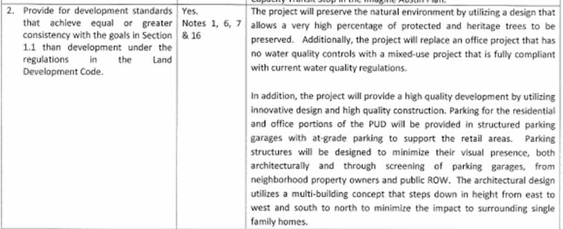
Image 1
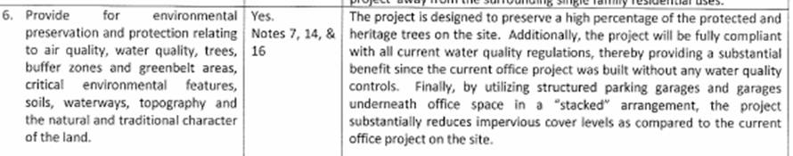
Image 2
|
27 Comments
 RSS Feed
